Page 1 of 2
GPS
Posted: 02:15 am Apr 23 2008
by rdsrf
Anybody use a GPS for trail ride exploration? I'd like to get one, but I'm having a hard time figuring out what would suit a motorcycle trail riding environment the best. Recomendations would be much appreciated!
Posted: 07:37 am Apr 23 2008
by KarlP
I've got a buddy that used one to map a trail section. He took the trace from the GPS and dropped it on a Google Earth satelite image of the area.
Pretty cool, but I think does nothing to answer your question
Posted: 07:41 am Apr 23 2008
by skipro3
Did you do a search on the word GPS here? There's quite a bit of info. I use a Garmin that mounts on my bars. Works great and when I'm back home, I can download to google earth and print maps.
Posted: 09:19 am Apr 23 2008
by saddletramp
Hey Ski, my tracks used to show up on google earth somehow, but now when I download my tracks they just stay in mapsource which has zero detail. I run the Garmin Legend cx.
Posted: 10:14 am Apr 23 2008
by skipro3
Check to see if the file extension is supported by Google. I had to save mine as the correct file type.
Posted: 11:11 am Apr 23 2008
by rdsrf
Skipro, what model GPS do you have? Being able to lay it down over Google earth would be very useful to me.
Posted: 02:09 pm Apr 23 2008
by KarlP
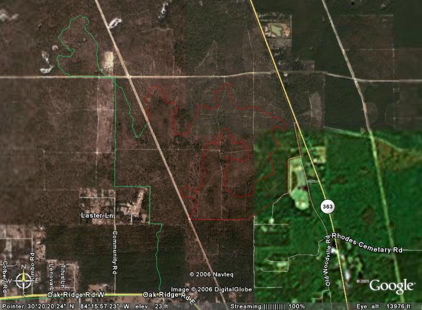
Google Earth is pretty handy for finding new riding areas.
Around here the population density is not very high. You can go on Google earth and find pockets and corners of areas where you might go in and cut trail. That's what we did around my neighborhood, anyway.
Some of our trails got taken over by Quads. They are now visible from a low earth orbit:sad:
Just have to watch out for shotgun toting moonshine operators and pot growers

Posted: 03:03 pm Apr 23 2008
by scheckaet
Posted: 03:11 pm Apr 23 2008
by Ogre
I love Garmin for on my Strom, but much prefer Lowrance for true off-road stuff.
Lowrance hold more points and tracks. The map details are better too.
It will also do google earth overlays with GPSbable
http://www.gpsvisualizer.com/gpsbabel/
Edit.. Oh FWIW my Lowrance H20 unit handles bike vibes better than any of my Garmin handhelds (the battery's would short out),
the screen is bigger and easier to see and the buttons are bigger and easier to use.
Posted: 03:41 pm Apr 23 2008
by pcoburn
Interesting comments - I have a Garmin Legend I tried when I went riding around West Virginia last year, but could get it to keep a lock - not sure if it was a problem with the way I had it mounted (don't see how, it was zip-tied to the crossbar so the antenna should have been in a good spot) or just that the trail was so dense the signal was blocked by the trees. Some of the trails were open, but most (and the ones I didn't want to get lost in and have a Deliverance moment) were narrow trails through the deep woods.
Posted: 09:27 pm Apr 23 2008
by skipro3
I have a Garmin GPSmap 60CSx
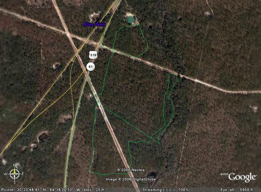
Here's a sample of a track I saved riding the Rock Creek OHV area. This is about a 40 Mile Loop ride for size perspective.

Posted: 09:36 pm Apr 23 2008
by skipro3
Here's another view showing the relief angle and how steep the canyons are

Posted: 09:45 pm Apr 23 2008
by Indawoods
That's awesome SKI! I had no idea those things are that useful...
Posted: 09:47 pm Apr 23 2008
by skipro3
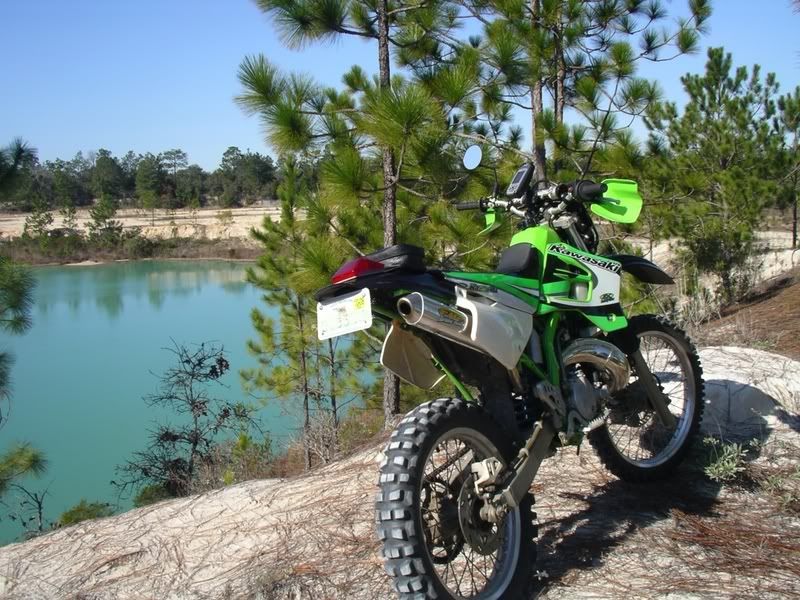
Here's a photo of Carvr's woods. Notice how steep this area is!! Geez! and y'all wonder why I had a little trouble.....

Posted: 09:51 pm Apr 23 2008
by skipro3
Another shot of Oregone!!
This is looking due north in case CC and Wib were trying to orient themselves to the map.
Also, I can e-mail this file from my GPS to anyone with the same device and they can upload it into their GPS and ride the same area, turn for turn that we rode.

Posted: 11:23 pm Apr 23 2008
by Mr. Wibbens
Thats sweet I can identify most of the trails
Posted: 11:27 pm Apr 23 2008
by skipro3
I'll bring my GPS cable next time and I'll show you what this thing can really do. I want to see the hill I had trouble with and the trail called "screwed by a tree"
Posted: 07:42 am Apr 24 2008
by KarlP
I have a couple of traces of trails in a more urban setting. We've got a 20 mile loop going that is pretty tightly packed on about 650 acres.
I can't figure out how to post a picture like Skipro can, though.
I get a little irritable when people lament the loss of riding areas. I've spent many hours CUTTING TRAIL in what would otherwise be wasteland, the kind of area that is used to dispose of household junk and burning stolen cars.
Posted: 09:06 am Apr 24 2008
by Ogre
>|QBB<[/url]
skipro3 wrote:Here's another view showing the relief angle and how steep the canyons are
Ski's shot here remined me of the other difference between Garmin & Lowrance.
Garmin tracks turn out with long straight line segments between points, lowrance tracks follow the exact curves of your path.
If its the only trail its not that big of a deal, but if the trails are packed in tight, it can be tough to follow a garmin track.
I can even see what side of a dirt road I was riding on. The tracks are noticeably separate.
I'd show you fancy elevations shots too......but its damn flat here

Actually these are my fancy elevation shots....cant you tell

Nice area you have to ride in Ski... I am jealous
Posted: 09:20 pm Apr 24 2008
by rdsrf
Any chance I can get some info on brands and model #'s? What has worked or hasn't worked. What can take the abuse of riding, what features are a must, mounted or hand held etc. Thanks for any help!