Does anyone here ever ride the Redbird Crest / Elisha Creek / Gilbert Creek trail system in Daniel Boone National Forest's Red Bird Ranger District in the southeastern reaches of Kentucky?
This massive, desolate, and remote National Forest OHV / Wildlife Management Area area very quickly became our favorite place to ride. Hardly any trail traffic, absolutely beautiful forest, massive hills & steep rugged terrain, with a good mix of fast-flowing trails and challenging steep rocky technical sections. This is about as good of a remote national forest wilderness type trail riding experience as you will find in the Eastern USA, I highly recommend it .
Although as the Forest Service website says, beginners must absolutely be accompanied by experienced riders, due to the steep challenging and technical nature of the terrain. Much of these trails are not terribly beginner friendly, although a lot of sections are (6A & 7A are probably the easiest, perhaps 7 now that they've finally done some tree clearing maintenance after 3 years).
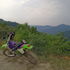
Here's a photo of yours truly, last July 4th, 2022, after running an unmarked trail off of trail 4 near Sugar Creek Trailhead, that takes you to the top of Lucindas Lookout Tower Rd where there are a few really nice graveled campsites 1.6 miles ride from the Sugar Creek Trailhead / restrooms.
Redbird_Crest-Lucindas_Knob_Lookout1.jpg (498.59 KiB) Viewed 77052 times
This point is a 900 ft elevation climb above the creeks at the base of these hills directly below (hence why it was the former location of a fire tower). The terrain regularly at Redbird Crest typically climbs anywhere from the creeks up 300ft, 400ft, to upwards of 900 ft between the creeks up to the peaks (lower elevations up to the higher points on the ridges) .
Here's a dreamy picture of some of the official single track riding to be had:
RedbirdCrestSingletracks.jpg (123.6 KiB) Viewed 77052 times
This is the favorite roadside camp spot on Sugar Creek Rd at what the locals call Old Woman's Rock, looking from fire pit towards the road:
same spot but looking from the tent/road side back towards the forest where there's a small creek behind the campsite:
I've found that most videos online on YouTube etc don't do these trails justice whatsoever, so I tried to take a few photos documenting what the video is don't show at all, a lot of rocky, steep, rugged, and beautiful terrain.
Here's a KDX200 video (not mine) from January 2nd 2023 (yes, it's rideable most of the winter as it's far enough South & not high enough elevation to get heavy snow). The rider is starting from upper Sugar Creek Rd onto Redbird Crest #801 trail section 4, and onto some unofficial singletracks, down to the lower section of Sugar Creek Rd at Peter's Branch Rd: https://www.youtube.com/watch?v=17CvIFYy93U
So many of the videos on YouTube just show a lot of faster easier sections, but I swear there are TONS of steep rocky technical sections here on the official trails, all over the place... I think a lot of video creators just post only the sections where the had no difficulty
Trail 1, not far from the gravel access road entry into the forest:
RedbirdCrestTrail1-July2022.jpg (544.39 KiB) Viewed 77052 times
Trail section 1 climbs nonstop, sidehilling up a steep, gorgeous, and rugged ravine nearly 600 feet of elevation all in one shot over what seems like an eternity (8/10ths of a mile)...
RedbirdCrestTrail1-July2022-2.jpg (396.89 KiB) Viewed 77052 times
Trail 6B right off of trail section 6:
RedbirdCrestTrail6B-2022.jpg (354.5 KiB) Viewed 77052 times
There's free camping at 2 of the 3 trailheads (Bear Creek Trailhead is not advisable for camping, but absolutely has some of the best trails around right out of the gate) and a few dispersed roadside sites throughout. There's also an RV / ATV Campground down US421 a short drive, connected through a maze of logging roads adjacent beyond the National Forest that eventually take you to the edge of the forest boundary where you can pick up Trail 6B.
There's also 6 RV hookup campsites with indoor running water restrooms (& showers?) in front of the Stinnett Community Center just down the road from an intersection of Trail 7 to the North end Trail 8/9 to the South.
Last edited by Chuck78 on 02:47 pm Jul 08 2023, edited 7 times in total.
Trail Section 11, and absolutely epic and very long ridge running section with some intense climbs up and down, at the well known and easily recognized powerline clearcut vista:
Redbird_Crest_Trail_11-March17-2023b.jpg (398.39 KiB) Viewed 77050 times
Redbird_Crest_Trail_11-March17-2023a.jpg (418.03 KiB) Viewed 77050 times
Here's a video from 6 months ago (not mine, one day I'll get an action sports video camera...) that highlights a really nice ridge running stretch of trail 11:
Note - as with most videos of Redbird on YouTube, this looks all fairly easy, but to run this section from the Oakley Cave Branch Cemetery down to Bear Creek Trailhead, requires fair bit of technical skill and finesse as there are some seriously steep sections and numerous intense rock gardens. The Hard Enduro Appalachia YouTube channel guy's Cincinnati area crew that we met at Redbird called that area the best trails in the whole forest...
This place has some amazing a fairly rugged trails to offer that we've found to be some of the best kept secrets in the Eastern USA for intermediate enduro riding, with some pretty challenging rocky climbs and singletracks as well. There's well over 150 miles of riding to be done here in this very remote National Forest area, with a 69 mile outer loop currently, making up the 22 trail sections of the Redbird Crest Trail #801 outer loop. Sections 14-15 are road connectors currently, (Sand Hill Rd area), but they will be re-routing the trail 801 loop route off the roads in the near future with primarily singletrack sections, and a few miles on old oil/gas access roads, from the end of trail 13 to midway into singletrack trail 16, the beginning/end of the official singletrack trails.
Their proposed reroute sections end up into the middle or northern portions of trail section 16, totalling 18 miles of new trails. The South portions of 16 will cut out of the loop and will perhaps be renamed 16B or just abandoned.
There's 30 more miles worth of official trail riding on trail sections 5A, 6A, 6B, and 7A which intersect the 69 mile Trail 801 outer loop at trail sections 4/5 junction and trail 6, as well as Peters Branch Rd (4wd road that's mostly just another nice dirt/rocky trail aside from a mile of gravel up to Peters Branch Cemetery), Gilbert Creek Rd or Gilberts Creek Rd depending on which map you look at, and Big Creek Rd (another 4wd road that's just another nice trail to run basically).
The 69+ mile outer loop of trail sections 1-22 is referred to as Redbird Crest Trail #801.
The inner trail areas on the Eastern side of the Redbird Crest Trails are officially referred to as Gilbert Creek/Elisha Loop Trail #802 (Trail Sections 5A & 7A) and Left Fork of Elisha Creek Trail #803 (Trail section 6A), & Daniel Boone Trail Connector #804 (trail section 6B) that ends at the National Forest boundary and has SxS/logging trails continuing onto the Boone Forest Lands Wildlife Management Area (very logged out) to the campground formerly known as the Willie Begley Memorial RV Park, now reopened under new ownership in the past 9 months.
Section 12 or 11?:
Redbird_Crest-Trail_12-11.jpg (599.44 KiB) Viewed 77050 times
Sections 6A and 7A are the only somewhat beginner-friendly trails there, with 1,2,3,4, and 5B being a lot of beginner friendly segments, but also mixed in with several areas of rocky steep challenging climbs. Trail section 7 now should be fairly beginner friendly, as I believe they've finally cleared it of many continual tree blockages (DOZENS & DOZENS) that had plagued it for nearly 3 years after numerous severe storms with heavy winds). It's a sidehill trail cut in just downwind from a north-south running tall ridge with a lot of big old trees on some very steep terrain, and suffers a lot of big old tree blow-downs. I believe they are going to eventually re-route that whole trail off of trail 7A, on the other side of the ridge it runs below now, to avoid the blow downs. They ran a mini dozer through there to move some of the big tree trunks out, so it should be easier now since the work in progress when we were there in mid March 2023.
Trail Section 11 rock gardens:
IMG_20230316_162836~2.jpg (403.11 KiB) Viewed 77050 times
Redbird_Crest_Trail_11-March17-2023d.jpg (555.06 KiB) Viewed 77050 times
I wouldn't recommend camping at the Bear Creek Trailhead on the south end (neither do the Rangers, and don't leave anything out and unlocked down there either), but WOW, some of the best hard enduro technical rocky steep trails are accessed off of the Bear Creek Trailhead. heading across the road on 12>11>10>9 will take you to some intensely steep climbs with several rock garden sections, and some amazing and easier ridge running sections up high. Not for the meak, on our 3 day trip, the first 45 minutes of riding for us in 2023 were making it up the first mile of trail, and it took many tries for my buddy to even get 1/4 mile into this section due to the steepness and technical nature immediately out of the trailhead going north trail 12>11... I got to ride that KDX200 many times up the hardest stuff that day, as well as riding the '07 KTM 200 XC-W... My KDX220R was the best suited tool for this terrain by far, especially the way I've got it set up.
There's also free camping, and not even really any mosquitoes, although you should treat your clothes and boots with Permethrin and use DEET or Picaridin to keep the chiggers off of you especially if camping in the forest at some roadside dispersed sites or at the trailheads.
There's a recently reopened RV campground (formerly Willie Begley Memorial RV Park) adjacent to the forest directly on US421 that has logging road SxS trails that lead to Redbird Crest/Elisha Creek trail section 6B, as well as 6 RV hookup sites in front of the Stinnett Area Community Center with just a short ride down a paved road and then a gravel>dirt road to the middle of trail section 6. Both of those places have showers and indoor restrooms, FYI!
Amazing rugged terrain with elevation reliefs upwards of 900ft from the creek beds to the tops of the ridges, which for all intents and purposes, a lot of people would call mountains.
Last edited by Chuck78 on 08:46 am Jul 08 2023, edited 5 times in total.
There's also a massive amount of old abandoned road grades as well as oil/gas well access roads and a couple dozen unmaintained forest service roads and county/township dirt roads in the area that aren't any different than a lot of the official 2-track trails, as well as tons of unofficial single.
old road grade with a singletrack path to some more traditional single:
single:
(not my vid)
Yours truly with my tough, lovely, and talented lady, at a pretty well hidden campsite just across a creek from Sugar Creek Rd, only 40 feet or less from the road but easy to drive past. Parking roadside, Jeep or small 4x4 pickup access and bike access only at the campsite, but lots of parking roadside in the grassy graveled area:
RedbirdCrest_SugarCreekRd2nd-westernCampsite07-04-2022.jpg (571.13 KiB) Viewed 77048 times
This hidden but almost roadside campsite is located at GPS coordinates 37.12322, -083.50260 - but...DO NOT try to follow Google Maps GPS there from the west! The maintained gravel road continues North from this campsite along the creek for a while, but Google Maps shows it following a dirt access road from the graveled road at the campsite off to the west/southwest... you can follow the Google Maps directions off of US421 to the Sugar Creek Trailhead and then there to this GPS above 37.12322, -083.50260 and it will get you there. 100 feet down the other road past an oil well tank, what Google displays as Sugar Creek Rd (which it is not past here) turns to rugged dirt 2-track.
I'm planning another Redbird Crest Kentucky / Daniel Boone National Forest trip mid-September, may head down mid August for a scouting run to see how the trail maintenance has been this year in terms of downed trees causing blockages etc. before I take some first-timers out there.
Also nearby the Redbird Crest Trail (1 hour north), I've gotten some feedback that the OHV-legal portion of the Sheltowee Trace Trail between S-Tree Campground on the south end and Turkey Foot Campground on the North end (which I've been very curious about for some time) is a very highly regarded section of trail, although this has some road connector sections, so technically a street plated bike is required. Also, the Renfro OHV Loop starts and ends at the S-Tree Campground. From the glowing positive responses I've gotten from a couple of riders about the Sheltowee Trace Trail OHV segment, it sounds like these guys REALLY LIKE that stretch of trail... So that's a pretty positive thing.
In addition to that, if you look up the "2019 Loose Nut Dual Sport" or the annual Renfro Valley Dual Sport on ADV Rider, you'll find more local routes listed as the hard/difficult sections there in the same vicinity. This area we may ride the Sunday and Monday of Labor Day Weekend.

 .
.